
How Drone Technology Supports Large-Scale Michigan Sitework Projects
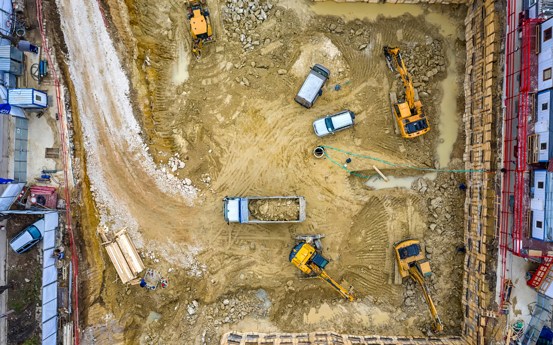
Drone technology is changing how contractors plan, monitor, and manage large-scale sitework projects. On commercial, municipal, institutional, and infrastructure sites, aerial data can help project teams understand existing conditions, track progress, identify risks, and coordinate field decisions more efficiently.
For Michigan projects involving excavation, grading, utilities, drainage, or complex site preparation, drones can provide a clearer view of the site before, during, and after major earthwork begins.
Drone technology does not replace experienced field crews, operators, survey teams, or project managers. Instead, it gives them better information to support smarter decisions across site work, grading and excavation, and large-scale infrastructure scopes.
Why Drone Integration Matters in Site Development
Large-scale sitework requires accurate information from the earliest stages of the project. Before crews begin moving soil, installing utilities, or preparing building pads, the project team needs to understand elevations, drainage patterns, access points, existing conditions, and potential conflicts.
Drone flights can collect aerial imagery and site data quickly, helping teams build a more complete picture of the property. This is especially valuable on larger sites where walking the full project area can take significant time and may still miss important details.
When drone data is paired with survey technology, construction teams can improve planning, communication, and progress tracking. This helps align the field with the design intent before major sitework activities begin.
Faster Site Surveys and Better Existing Conditions Review
Traditional site review can be time-consuming, especially on large or uneven properties. Drones can help speed up the process by capturing aerial views of the full site, including areas that may be difficult to access on foot.
For early site development, drone imagery can help document:
- Existing grades and elevation changes
- Drainage patterns and low areas
- Vegetation, tree lines, and clearing limits
- Access routes and staging areas
- Existing pavement, structures, utilities, or site obstacles
- Soil disturbance and erosion-prone areas
- Progress between construction phases
This information can support better planning for site preparation and development, especially when the project includes clearing, grading, drainage work, utility corridors, or road improvements.
Supporting Mass Grading and Cut-and-Fill Planning
Mass grading depends on accurate earthwork planning. Crews need to understand where soil will be cut, where it will be placed, how grades will change, and how the finished site should drain.
Drone-supported data can help project teams compare existing site conditions with grading plans. This can improve planning for material movement, haul routes, stockpiles, staging areas, and equipment access.
For large Michigan projects, mass grading services often involve moving significant volumes of material. Aerial data can help teams monitor progress and reduce the risk of over-excavation, missed areas, or inefficient soil movement.
Once broad earthmoving is complete, drone imagery can also support follow-up review before fine grading services, aggregate placement, paving, landscaping, or final restoration begin.
Real-Time Site Monitoring During Construction
Drones are not only useful before construction starts. They can also help monitor active sitework and document progress throughout the project.
Regular drone flights can give owners, general contractors, engineers, and field teams a visual record of how the site is changing. This can be especially helpful on large projects where multiple crews, utilities, haul routes, and work zones are active at the same time.
Drone monitoring can help project teams identify:
- Progress compared with the planned schedule
- Areas where grading or drainage may need adjustment
- Access issues for crews, equipment, or deliveries
- Potential conflicts between utility work and sitework activities
- Safety concerns around traffic, slopes, trenches, or active equipment zones
- Areas that may need cleanup, stabilization, or restoration
When this information is connected to project management integration, it can help teams communicate field conditions faster and make better decisions before small issues become schedule problems.
Improving Safety Without Slowing the Project
Large-scale sitework often involves heavy equipment, open excavations, utility trenches, haul routes, changing grades, and multiple active work zones. These conditions require strong safety planning and clear site visibility.
Drones can help project teams observe hard-to-reach areas without sending people into active equipment zones or unstable terrain unnecessarily. Aerial views can also help supervisors review traffic flow, work zone separation, stockpile placement, trench locations, and access routes.
Drone footage should not replace field safety procedures, inspections, or crew communication. But it can support safer decision-making by giving the project team another way to see what is happening across the site.
Utility Layout, Trenching, and Underground Coordination
Utility work is one of the areas where early visibility can make a major difference. Underground utilities must be coordinated with grading, building locations, roadways, drainage, access, inspections, and future maintenance needs.
Drone imagery can help teams understand how utility corridors fit into the full site layout. This is useful when planning utility trenching, water main installation, sanitary sewer installation, and storm sewer installation.
For large or complex projects, aerial views can also help teams coordinate material staging, equipment access, trench sequencing, backfill areas, and restoration limits. This reduces the chance that utility work will conflict with grading, paving, drainage, or other sitework activities.
Drainage and Environmental Planning
Michigan sitework projects often need careful drainage and erosion control planning. Seasonal rain, snowmelt, freeze-thaw cycles, disturbed soils, and changing grades can all affect how water moves across a construction site.
Drone imagery can help identify drainage paths, low areas, erosion-prone slopes, sediment movement, and areas where water may collect. This information can support better planning for stormwater management, erosion control, temporary access, and construction sequencing.
For projects that include stormwater infrastructure, drone-supported review can be coordinated with storm sewer installation, grading, and site restoration. The goal is to keep drainage planning connected to the full sitework process, not treated as a separate problem at the end.
Reducing Material Waste and Cost Overruns
On large grading and excavation projects, small measurement errors can create expensive consequences. Over-excavation, unnecessary haul-off, poorly placed stockpiles, and inefficient material movement can all increase cost and slow the schedule.
Drone-supported site data can help project teams understand how much material is being moved, where material is staged, and whether the site is progressing as planned. This can help reduce guesswork during excavation, grading, and restoration.
When paired with experienced operators and the right equipment, better site data can support more efficient field decisions. This matters on projects where earthmoving, utilities, and access planning all need to work together.
Integrating Drone Data with Construction Software
Drone data becomes more useful when it is integrated into the broader project management process. Aerial imagery, progress photos, topographic information, and field documentation can help owners, engineers, contractors, and inspectors stay aligned.
Depending on the project, drone data may support CAD coordination, digital reporting, progress documentation, stakeholder updates, and comparison between planned and actual site conditions.
For large-scale sitework, this creates a stronger single source of truth for the project team. Instead of relying only on written updates or isolated field observations, teams can use visual documentation to understand where the project stands and what needs attention next.
Where Drone Technology Adds the Most Value
Drone technology can support many types of construction projects, but it is especially useful when the site is large, complex, phased, or difficult to monitor from ground level alone.
Common use cases include:
- Large commercial site development
- Municipal and public infrastructure projects
- Institutional campuses, schools, and public facilities
- Road reconstruction and utility corridor projects
- Mass grading and earthmoving scopes
- Stormwater, water main, and sanitary sewer projects
- Projects with multiple phases, crews, or stakeholder groups
In each case, drone technology helps turn field conditions into usable information that can improve planning, communication, and accountability.
Project Experience and Field Execution Still Matter
Drone technology is only valuable when the project team knows how to use the information. Aerial imagery can show what is happening, but experienced contractors still need to interpret the conditions, make field decisions, and execute the work correctly.
Verdeterre’s project experience includes sitework, grading, utility, and infrastructure scopes across Michigan. The Monroe County MDOT Facilities project involved earthwork, new storm sewer, water main, and sanitary sewer systems across multiple ground-up facilities. The Auburn Road Reconstruct – MDOT 38 project included water main installation, earthwork, and road reconstruction. The Hilltop Apartments for Avalon Housing project included sitework, stormwater, water, and sanitary sewer systems for a multi-building development.
Projects like these show why technology, field experience, equipment, and coordination need to work together. Drones can improve visibility, but strong execution still happens on the ground.
Building Smarter From the Sky and the Ground
Drone technology helps large-scale Michigan sitework projects move with better visibility, better documentation, and better coordination. From surveying and grading to utilities, safety, drainage, and progress monitoring, aerial data can support smarter decisions throughout the construction process.
For owners and project teams, the value is not just having drone footage. The value comes from using that information to improve planning, reduce risk, communicate clearly, and keep the project aligned with real site conditions.
Verdeterre supports commercial, municipal, institutional, and infrastructure clients with site work, commercial excavation, site utilities, grading, trenching, restoration, equipment, survey technology, and project management integration throughout Michigan.
Explore our services or review our project profiles to see how Verdeterre combines field experience and construction technology to support complex sitework from the ground up.