
Drone technology is rapidly changing the way contractors approach large-scale construction across the country, and it’s making a particularly strong impact in Michigan sitework projects. From detailed surveying to real-time monitoring, drones help construction teams improve efficiency, accuracy, and coordination—especially on jobs involving Michigan mass grading.
Whether it’s a public infrastructure project, a new school build, or a large commercial site, drones are proving to be a valuable asset in modern construction sitework Michigan professionals depend on to keep complex projects moving forward.
Why Drone Integration Matters in Site Development
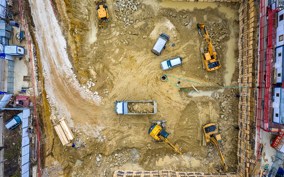
Large-scale sitework requires precision from the very first phase. Before any machines can move dirt, they need to get a good look at the land and make a model of it. In the past, this process involved long ground surveys in which crews had to physically mark and map the area. This phase has taken a lot less time and work thanks to drone technology.
A drone can collect thousands of data points in a single flight. High-resolution cameras and LiDAR (Light Detection and Ranging) sensors mounted on drones generate detailed 3D maps and topographical models of a job site in just hours. These digital maps support better planning and provide engineers and contractors with a clear, measurable understanding of what the site needs before grading begins.
This is especially helpful for mass grading projects in Michigan, where changes in terrain and elevation need to be carefully planned for good drainage and stability under load.
Faster, More Reliable Surveys
When working on a large site in Michigan, survey speed and accuracy are very important. Things that used to take days or weeks can now be done in just one or two flights over the land. For instance, a drone can fly over 50 acres of land and gather millions of data points in just a few hours, which makes it much faster to make a site plan.
In addition, drone-generated data is often more accurate than traditional surveying methods.
To set standards, figure out slope angles, and figure out cut-and-fill volumes, you need this level of accuracy. Because of this, Michigan mass grading needs to be done with exact amounts of earthmoving to stay on schedule and on budget.
Real-Time Site Monitoring
Because they can monitor the site and track progress, drones are still useful after excavation and grading are complete. By using drones to take aerial photos, construction managers can compare the site’s current state with the original utility or grading plans. As a result, deviations can be quickly identified and fixed by project managers before they affect the timeline as a whole.
For large institutional builds, such as schools, medical centers, or government facilities, the need for coordination across teams and timelines is critical. Drone footage gives teams a live look at how the site is evolving, which helps identify potential slowdowns, safety hazards, or drainage issues before they escalate.
Improving Safety Without Slowing Progress
Large-scale construction sitework Michigan projects often involve dozens of workers and machines spread over expansive terrain. This type of work environment presents distinctive safety challenges. Drones provide a safer and more efficient alternative to sending supervisors on foot to inspect hard-to-reach areas or active equipment zones.
From above, drones can monitor site traffic, equipment movement, and personnel locations, reducing the risk of accidents. Teams can watch the footage to make sure everyone is following safety procedures and that work areas are clearly marked.
Drones can also help keep track of how well local safety and environmental rules are being followed. This is an important part of big projects in Michigan, like those run by the government or big companies.
Supporting Utility Layouts and Environmental Planning
Drones do more than assist with terrain mapping and safety—they also help coordinate utility placements and environmental features. Aerial imagery gives planners a clear view of how the site fits into its surrounding area. It helps identify natural drainage paths, tree lines, and potential water retention zones.
On Michigan construction sites with water main, sewer, or stormwater infrastructure, drone mapping helps figure out where to dig and where to put utilities. The visual summary helps you make better choices about where to put materials, how to get to equipment, and how to move people during the installation.
In areas prone to seasonal rain or snowmelt, drones also help spot erosion-prone locations so contractors can plan sediment control strategies early in the grading process.
Reducing Material Waste and Cost Overruns
When every yard of soil counts, drones can help crews stay on track. With accurate aerial data, construction teams can determine how much material is required, where it is coming from, and where it is going. This reduces over-excavation and waste (both material and fuel).
For Michigan mass grading projects that involve balancing large volumes of cut and fill, drone-assisted modeling provides up-to-date information for machine operators and site planners. This helps keep costs low while keeping productivity high, especially on long-term projects that last through more than one season.
Integrating Drone Data with Construction Software
One of the best things about using drones is how easily the data can be added to modern building programs. CAD models, BIM files, and GIS systems can all pull drone-generated imagery and topographic data into their systems. This simplifies reporting and provides a single source of truth for all team members—from engineers to operators to clients.
For large-scale construction sitework Michigan projects, this integration saves time, eliminates guesswork, and helps contractors stay ahead of the curve with better forecasting and planning tools.
Building Smarter From the Sky
Drone technology is not supplanting skilled contractors or conventional equipment; rather, it is augmenting them by providing enhanced data, safer job environments, and expedited workflows. In an industry where time, cost, and safety are paramount, drones are effecting significant change.
As Michigan sitework projects increase in complexity and magnitude, the utilization of drones is expected to transition from a competitive advantage to a standard expectation. Contractors incorporating aerial technology into their mass grading operations in Michigan enhance precision, adhere to timelines, and optimize project management.